S02|09 - The RADARSAT Constellation Mission
08/21/20 • 50 min
Just how many black rhinos could Canada launch into orbit? What exactly is a satellite constellation? What is the Canadian Space Agency doing to help protect Canadians from natural disasters? With the help of special guest Geneviève Houde, Systems Engineer for the CSA, we answer all of these questions in this week’s episode.
Nearly all of our episodes so far have focused on civil engineering monuments, and certainly all of them have been securely planted on earth. With this episode taking us off-planet and into orbit we have an opportunity to break down the difference between Civil Engineering and other disciplines needed for projects like the RADARSAT Constellation Mission (or RCM) such as Mechanical Engineering. The short version? If it moves, it’s not civil! So to make sure we’ve got all our facts straight we talked with CSA Systems Engineer about her history with the Canadian Space Agency and how the RCM works.
The RCM is project 15 years in the making, and an effort of 300 people from 50 companies across Canada, and 125 suppliers from 7 different provinces. This nationwide project reached earth’s orbit with the help of SpaceX’s Falcon 9 rocket in June 2019 and became fully operational in November. The “constellation” in RCM refers to this mission being made up of three separate satellites that circle the globe every 96 minutes, with their orbits evenly spaced to provide near complete coverage of the earth at any time.
These satellites are just 3.6m high, barely 1m wide, and just under 2m deep, and weighing 1430kg each, roughly the weight of a black rhino! They orbit the earth at 600km high, twice the distance of the ISS, and their tiny size and massive distance combined makes them naked to the human eye. But this distance is no obstacle for the RCM’s imaging technology, and neither is smoke, rain, clouds, or other atmospheric obstructions. Using Synthetic Aperture RADAR the RCM sends packets of information to earth which reflect back up to the satellites for three main purposes: maritime surveillance, disaster management, and ecosystem monitoring.
Surveillance can be a bit of a scary topic, so we take some time to ease John’s conspiracy concerns while also discussing how you can access the RCM’s images yourself, with the help of a resource provided by the CSA.
—
Geneviève Houde: bio | headshot
Canadian Space Agency: website | facebook | twitter | instagram | RADARSAT Constellation Mission Project | how to access RCM images
—
Image Gallery
Image of the RADARSAT Constellation | RCM vibration testing | RCM Illustration
Image Credits: Canadian Space Agency
Image Credit: SpaceX
—
Learn more at: MeasuredInMetric.com | Facebook | Instagram
Music by: John Julius - Bandcamp.com
Edited by: Astronomic Audio
Previous Episode
S02|08 - The Port of Buenos Aires
This episode comes via special request from a listener, and is the first engineering project of its kind on the podcast: The Port of Buenos Aires.
Being the first port on the podcast we get the opportunity not just to discover the history of the project itself but also to learn about the complex multidisciplinary field of port engineering. This field requires a wide array of expertise ranging from naval architecture and the hydrodynamics of ships to geotechnical engineering, record keeping, security, navigation, logistics, and much more.
Located in the capital of Argentina, the Port of Buenos Aires handles as much as 85% of the cargo shipped into the country today. However getting to this point the project had to work through a great deal of bad luck and unfortunate timing. When Buenos Aires was first established as a port city by the Spanish back in 1580, the water level along the coastline required passengers and goods to be transferred from larger ships to smaller ships and then brought to shore.
Nearly 3 centuries later in 1868 the Argentine congress commissioned technical studies to build a more modern port in order to support more modern trade. As with many projects, this was held up by internal politics for a full 3 years, but eventually a pier was built that stretched out into the water so smaller ships could dock there, a method that is still seen around the world particularly in tourist destinations. In 1884 the design of a major 4 dock complex would be started by Sir John Hawkshaw, the former president of the UK’s Institute of Civil Engineers. The first of these 4 docks would be completed in 1888 and just two years later Argentina would be hit by The Panic, a financial crisis resulting from a London bank facing bankruptcy as a result of taking on risk on poor investments in Argentina. While ultimately Argentina was able to recover from The Panic it would severely delay the construction of the port, stretching out the completion of the project to 1897.
The turn of the 20th century was sa time of rapid advancement and quick progress, which unfortunately meant the port would quickly be obsolete for servicing new larger ships and it had completely reached capacity by 1907. Plans for new docks would be approved in 1911 but these plans were also severely delayed, this time by the first World War. These expansions were finally completed fifteen years later in 1926, and those expansions are largely how the port remains today.
—
Learn more at: MeasuredInMetric.com | Facebook | Instagram
Music by: John Julius - Bandcamp.com
Edited by: Astronomic Audio
Next Episode
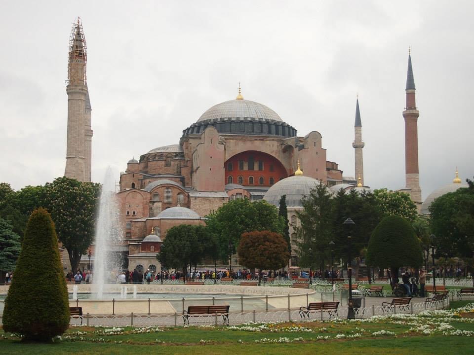
S02|10 - Hagia Sofia
From Basilica to Cathedral to Mosque to Museum, this episode’s monument spans across 1,600 years, multiple empires, and centuries upon centuries of dedicated engineers and architects keeping it in proper repair: The Hagia Sofia
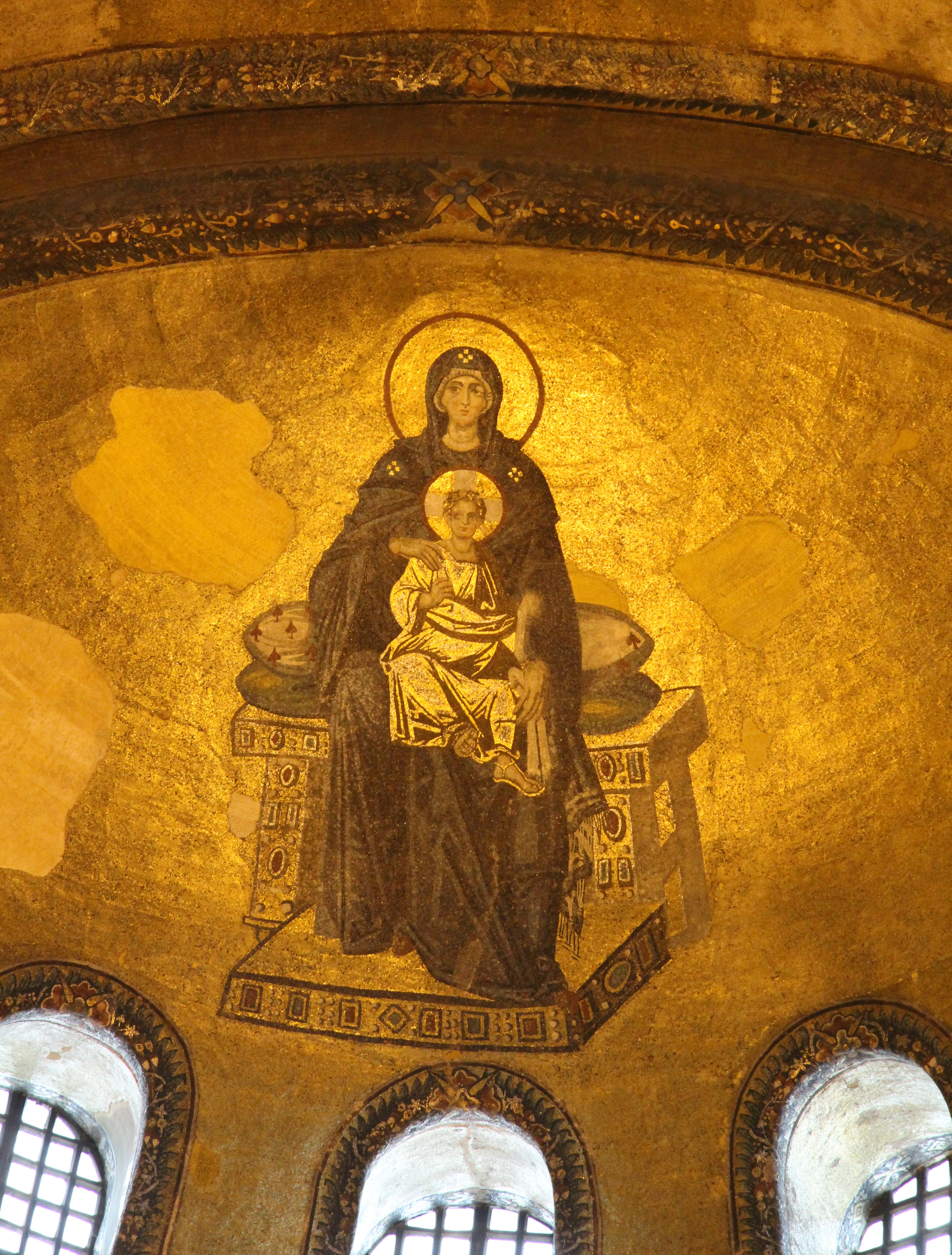
In the city that today is known as Istanbul, the first iteration of the Hagia Sofia was built in 360AD, at a time when the city was still known as Byzantium. Constructed out of wood, it was burned to the ground during riots, then rebuilt once again out of wood in 415AD only to be once again burned during riots. Then in 537AD under Eastern Roman Emperor Justinian I, and supervised by engineer Anthemius of Tralles the Hagia Sofia was rebuilt out of stone, and has stood to this day.
Under the Eastern Roman Empire, each new Emperor would add to, repair or extend the Hagia Sofia, up until the 13th century when the city and the Hagia Sofia itself were looted by the Venetian Crusaders. All the gold and silver were stripped from the building and it would be converted in purpose from a Byzantine Orthodox Basilica to a Roman Catholic Cathedral as the city changed from Byzantium to Constantinople.
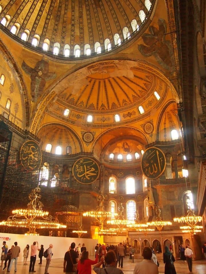
The now Cathedral would change hands again when Constantinople was conquered by Mehmed II and renamed to Istanbul, this time changing from a Catholic Cathedral to an Islamic Mosque. Under Mehmed II additions would be made such as wooden minarets, it’s famous giant chandelier, and some additional parts to facilitate Islamic prayer traditions. Painting of Jesus and other Christian iconography was covered with plaster rather than removed or destroyed, which allowed for these icons to later be restored prior to the Turkish president secularizing the building in 1934 and turning it into a Museum. History for the monument is still being written, as just this year Turkish President Erdogan has covered it back to a Mosque, with Christian imagery this time concealed behind curtains.
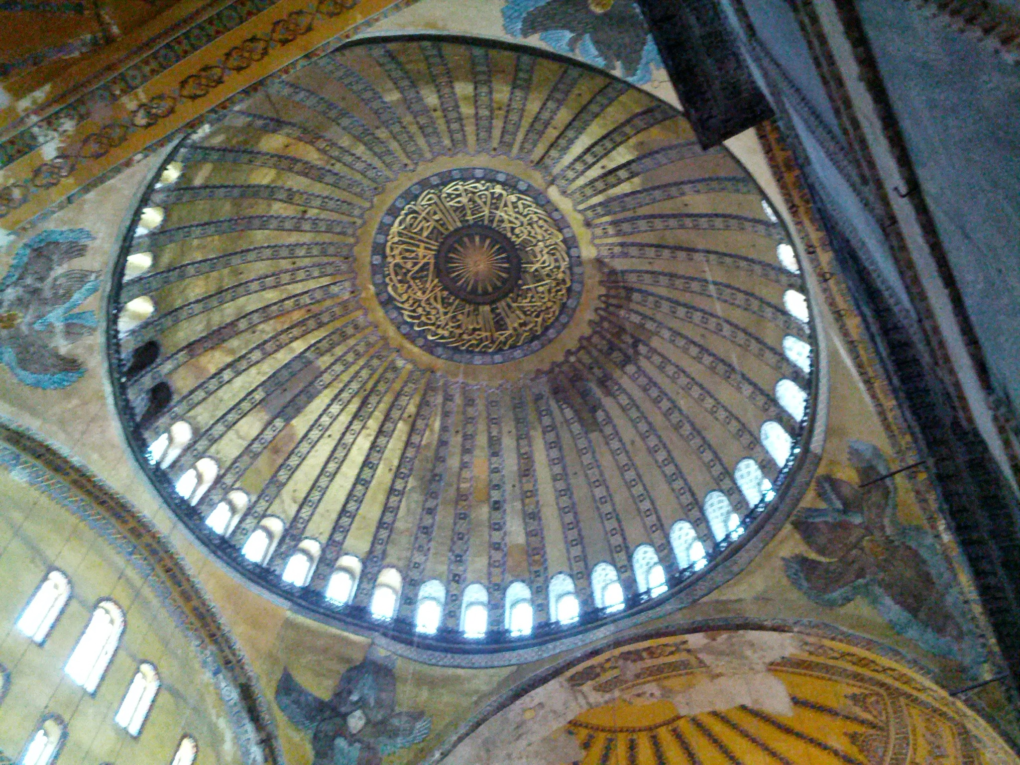
Beyond the monument’s changing hands, the Hagia Sofia provides us an opportunity to learn about the Eastern Roman building techniques the allowed for the monument’s iconic and surprisingly thing dome, 6th century fireproofing methodology, and some theorizing around how Pi would have been approximated at this time in history.
—
Image Gallery
Mary & Jesus Mosaic | Dome and Pendentives | Interior with crowd | Islamic Symbols and Christian Mosaic side by side | Exterior view of Hagia Sofia | A very young Vivian & John
—
Learn more at: MeasuredInMetric.com | Facebook | Instagram
Music by: John Julius - Bandcamp.com
Edited by: Astronomic Audio
If you like this episode you’ll love


Episode Comments
Generate a badge
Get a badge for your website that links back to this episode
<a href="https://goodpods.com/podcasts/measured-in-metric-392659/s0209-the-radarsat-constellation-mission-55488999"> <img src="https://storage.googleapis.com/goodpods-images-bucket/badges/generic-badge-1.svg" alt="listen to s02|09 - the radarsat constellation mission on goodpods" style="width: 225px" /> </a>
Copy