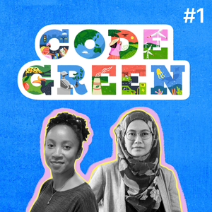
01: Geospatial AI and Emerging Opportunities for Climate Action
10/01/24 • 45 min
Geospatial AI is the use of AI-based tools for analysing any type of geographic information derived from sources such as satellite imagery, aerial drones, and geographic information systems (GIS). These technologies can be employed in resource management, disaster response, and conservation efforts, offering real-time monitoring and analysis of ecosystems and natural resources.
In this episode, we explore the potential and limitations of using Geospatial AI for climate action. The conversation ranges from trends in democratisation of map-making with easy-to-use GIS tools to the risks and ethical concerns that are associated with the use of GIS data. Our guests discuss the need for community involvement, factoring in local knowledge systems, and ensuring equitable access when it comes to Geospatial AI. They discuss the potential environmental costs and the importance of funding and transparency in technology implementation.
You can read the transcript for this episode here.
Speakers
Cathy Richards
Cathy is the Associate for Digital Resilience and Emerging Technology at The Engine Room. Recently, as a Green Web Fellow, she investigated the benefits, ethical questions, and security risks associated with using GIS for environmental justice. Cathy holds a Bachelor's degree in International Relations from Boston University and an MPA from the Monterey Institute of International Studies. She is from Costa Rica.
Izni Zahidi
Izni is a Civil Engineering academic at Monash University, Malaysia and has over 16 years of academic and industry experience. Her primary research is in using remote sensing, GIS, and modelling to develop sustainable and climate-resilient communities. Her research team assesses environmental risks such as flooding, water pollution, vegetation degradation, and urban heat island effect to improve natural resources management. Her research work has won a Gold Award, Silver Award, and Special Award as selected by the Toronto International Society of Innovation and Advanced Skills in the international competition, Sustainability in Civil Engineering Exhibition and Competition.
Show Notes
Geospatial AI or Geo AI (glossary term)
ArcGIS, Esri’s enterprise geospatial platform
QGIS, a free and open-source platform
Felt Maps, a cloud-native platform
Artificial intelligence for predicting urban heat island effect and optimising land use/land cover for mitigation: Prospects and recent advancements, research paper co-authored by Izni Zahidi
Modelling public social values of flood-prone land use using GIS application SolVES, research article co-authored by Izni Zahidi
Internet of Things or IoT (glossary term)
Tracking Amazon: How Neighbors Are Monitoring Pollution From New Delivery Hub
Wireless Sensors Could be Less Effective in Muddy Soil
How the “Internet of Cows” is Transforming Livestock Farming in Europe
Northern Kenya leads the way in the world's largest IoT conservation network
Previous Episode
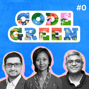
00: Navigating AI’s role in Asia’s Climate Action Strategy
The climate crisis has pushed parts of Asia past a tipping point, making urgent solutions critical. While tech solutions like AI-driven smart agriculture and energy management are emerging, there's little understanding of the extent of their adoption and impact. How will AI fare in contexts underscored by issues of digital divide, data challenges and financial gaps?
In episode zero of the Code Green podcast, we speak to leading experts on the intersection of AI and climate action in Asia from a policy, technology and finance lens. Our guests highlight the many opportunities for AI in climate adaptation, environmental costs and pathways needed to ensure climate justice in the long run.
Speakers
Elina Noor, Senior Fellow, Asia Program, Carnegie Endowment for International Peace
Elina's work focuses on developments in Southeast Asia, particularly the impact and implications of tech in reshaping power dynamics, governance and nation-building.
She's been the director of political-security affairs and deputy director of the Washington DC office at the Asia Society Policy Institute; and associate professor at the Daniel K. Inouye Asia-Pacific Center for Security Studies in Honolulu.
Elina has spent most of her career at the Institute of Strategic and International Studies Malaysia, last as director, foreign policy and security studies. She was also with the Brookings Institution’s Project on US Relations with the Islamic World, and currently serves on the UN Sec-Gen’s Advisory Board on Disarmament Matters.
Alpan Raval, Chief Scientist AI/ML, Wadhwani AI
Alpan is a theoretical physicist, in the applied AI space for the last 24 years, applying ML to problems in computational biology and chemistry, queuing, computational advertising, online newsfeed optimisation and content moderation, public health, and agriculture.
Alpan has led applied AI teams at LinkedIn and Amazon, worked as a researcher at D E Shaw Research; and taught mathematics and computational biology at the Claremont Colleges in California. He is the co-author of Introduction to Biological Networks (CRC Press).
Varad Pande, Partner, Boston Consulting Group
Varad is a leader in BCG’s Climate & Sustainability and Social Impact practices with a focus on emerging markets. He is part of BCG’s Asia leadership team for social impact, climate finance, and adaptation and resilience. He has over 20 years of global experience as a senior ministerial advisor, an impact investor, and strategy consultant.
Varad’s work has spanned UN Sustainable Development Goal domains such as financial inclusion, agriculture and livelihoods; and he has helped shape the global discourse on the role of digital public infrastructure (DPI) in accelerating the achievement of the SDGs.
Varad was formerly a Partner at Omidyar Network India, and a partner and Asia Leader at Dalberg.
This podcast is accompanied by a monthly newsletter - sign up here.
Find the transcript here and visit codegreen.asia
Credits
Audio Editing: Sharon Joseph
Production Support: Shivranjana Rathore
Attributions
Intro, Outro - Retro Sounds, Alban_Gogh
Transitions - Meditative Background Music, white_records
Show notes
Check out resources referenced in the episode:
IEEE portfolio of AIS technology and impact standards and standards projects
International Standard on information Technology-Artificial Intelligence-Management System
Nikshay Platform for Tuberculosis
E-Sanjeevini for doctor-patient consultation
Next Episode
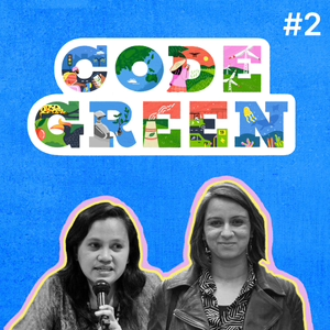
02: Agriculture 4.0 & the Future of Asia’s Farmers
Climate change is disrupting agricultural practices, affecting food security and farmers' livelihoods. Technologies like AI-enabled precision agriculture are emerging as potential solutions to alleviate some of these problems. In Asia, where most farmers are smallholders and a digital divide persists, what are the implications of AI adoption for agriculture in the region? Can it help address the climate crisis or is it likely to exacerbate existing inequities?
In this episode, we deep-dive into the opportunities, challenges and risks of using AI for agriculture and how it might impact climate change. For the most part, our speakers are sceptical about the use of AI for agriculture, highlighting that it may not be what farmers need and ultimately serves narrow commercial interests. If we are to use AI for agriculture, we need to resist the fail-fast logic that dominates the start-up industry and invest the time and resources to engage with farming communities and understand their needs and social context.
You can read the episode transcript here.
Speakers
Anubha Singh
Anubha is a PhD candidate at the School of Information at the University of Michigan with a graduate certificate in Science, Technology, and Society. Through long-term ethnography of the onion supply chain in Western Maharashtra, she studies how data-driven technologies are restructuring farming and redefining the future of agriculture in India. Her work is informed by and contributes to the fields of Postcolonial and Feminist Science and Technology Studies, Ethnography of Computing and Agriculture, and Critical Cultural Studies.
Elenita ”Neth” Daño
Elenita, also known as Neth, is the Asia Director of the ETC Group that works to address the socioeconomic and ecological issues surrounding new technologies that could have an impact on marginalised communities. Neth is a researcher who has done in-depth analysis and published work on various issues in agriculture and climate change as well as technological divides, in developing countries, particularly in Southeast Asia. She has represented environmental non-governmental organisations in the Advisory Board to the Climate Technology Centre and Network (CTCN), the operational arm of the Technology Mechanism of the UNFCCC. She was appointed by the UN Secretary-General in the 10-member Group that supports the Technology Facilitation Mechanism (TFM) in 2016-2017.
Show Notes
A commentary on agricultural digitalisation for climate action in the Philippines. Page 17. Expert brief authored by Elenita Dano for the AI + Climate Futures in Asia Project.
The Green Revolution is a warning, not a blueprint for feeding a hungry planet
Digital Agriculture Mission: Tech for Transforming Farmers’ Lives Agristack and digital registry of farmers in India
Indian Government Seed Fund Scheme for Start-up Prototypes
The Politics of Manmohanomics 1991 Economic Liberalisation in India
Agriculture sector has done well, needs ‘re-orientation’
A commentary on agricultural digitalisation for climate action in the Philippines. Page 14. Expert brief authored by Elenita Dano for the AI + Climate Futures in Asia Project.
If you like this episode you’ll love


Episode Comments
Generate a badge
Get a badge for your website that links back to this episode
<a href="https://goodpods.com/podcasts/code-green-579423/01-geospatial-ai-and-emerging-opportunities-for-climate-action-75492488"> <img src="https://storage.googleapis.com/goodpods-images-bucket/badges/generic-badge-1.svg" alt="listen to 01: geospatial ai and emerging opportunities for climate action on goodpods" style="width: 225px" /> </a>
Copy