
#16 - James Kavanagh - Surveying and Geospatial Insights
07/12/23 • 51 min
About this Podcast
Join host Steven in an exciting episode of the BimTube podcast as he interviews James Kavanagh, a survey and geospatial expert, who is a Director from RICS (Royal Institution of Chartered Surveyors).
- BimTube website: http://bim.tube
- Royal Institution of Chartered Surveyors (RICS): https://www.rics.org/
- Earth observation and aerial surveys - RICS PROFESSIONAL STANDARD
Global, 6th edition, September 2021, Effective from 4 January 2022
https://www.rics.org/profession-standards/rics-standards-and-guidance/sector-standards/land-standards/earth-observation-and-aerial-surveys
Discover James' journey into the field, from land surveyor training to working on ground-breaking infrastructure projects. Dive into the evolution of geospatial technology, including GIS and GPS positioning, and the critical role of data currency and provenance. James emphasizes the need for professionals to understand client requirements and provide effective data management solutions. Learn about RICS' imagery guidance for procurement and gain insights into integrating sensors and ensuring accuracy in geospatial data capture.
Explore the expanding role of geospatial skills in various industries and how advancements in technology have revolutionized the field. Discover the vital role of geospatial information in achieving the United Nations Sustainable Development Goals, from poverty reduction to social justice. Don't miss this captivating conversation on geospatial knowledge and its impact on society.
About James Kavanagh BSc (Hons), MRICS, C.Geog
James is a Chartered Surveyor & Chartered Geographer. James studied Survey & Mapping at DIT Dublin, Ireland and University of East London. He has worked on some of the largest civil engineering projects in Europe, including Canary Wharf and Broadgate - London and spent several years mapping Palestinian refugee camps in the Middle East whilst working for the United Nations. James has broad experience of surveying in many countries around the world, including Ireland, UK, Belgium, the Seychelles, Palestine, Philippines, Syria, and Egypt. James is currently global Director of Land, within the Professional Groups and Forums department of The Royal Institution of Chartered Surveyors (RICS).
- James on LinkedIn: https://www.linkedin.com/in/james-kavanagh-65448b17
====
GET THE INTERNATIONAL INFORMATION MANAGEMENT 'BIM' STANDARDS!
ISO 19650 series and UK BIM Framework: http://www.iso19650.org/
====
Links and Resources
- Sustainable Development Goals (SDGs): https://sdgs.un.org/goals
- What is Global Positioning System (GPS)?:
Contact the BimTube Podcast by sending us a text message.
BimTube's Mission: "We want to build everyone’s digital knowledge with content and conversations to inspire and instigate 'Better Information Management' to enable - better decisions, better infrastructure, better services and better outcomes for our social, economic and environmental infrastructure."
- Visit the BimTube Podcast page: https://www.bim.tube
- BIM / ISO 19650 Training (sponsored): https://www.bimenable.com
Previous Episode

#15 - Gary Nuttall - Developing Digital Trust
BimTube website: http://bim.tube
Welcome to this episode of the BimTube podcast. Today, our guest is Gary Nuttall, MBCS CITP, an emerging technology consultant. Gary shares his background in analytics and his journey to becoming an independent consultant. The podcast host, Steven, and Gary discuss the concept of distributed ledgers and blockchain technology. Gary explains that a ledger is a record of transactions, and a distributed ledger is a single ledger shared among multiple participants. They touch upon the idea of public and private ledgers, where the access to the ledger can be restricted.
In addition, Gary explains that parametric insurance is based on specific parameters or trigger events, such as flight delays or crop damage due to excessive rain. It utilizes smart contracts on blockchain or distributed ledger systems to automate the compensation process. They discuss the efficiency and speed of parametric insurance compared to traditional insurance, highlighting examples like flight delay insurance and crop protection insurance.
About Gary and Distlytics
Distlytics Ltd is a consulting firm founded in 2016 by Gary Nuttall, a recognized figure in the field of Blockchain and Distributed Ledger Technology. With expertise in commercial insurance and legal sectors, Gary has been listed as one of the "Top 100 Blockchain influencers" and has spoken at various conferences and events since 2015. He is known for his articles on emerging technologies, particularly focusing on blockchain.
Gary on LinkedIn: https://www.linkedin.com/in/garynuttall/
Distlytics Ltd: https://www.distlytics.com/aboutdistl...
-------------------------
Links Mentioned by Gary
- What is New in the 2022 Gartner Hype Cycle for Emerging Technologies
https://www.gartner.co.uk/en/articles...
- GTC - The Conference for the E
Contact the BimTube Podcast by sending us a text message.
BimTube's Mission: "We want to build everyone’s digital knowledge with content and conversations to inspire and instigate 'Better Information Management' to enable - better decisions, better infrastructure, better services and better outcomes for our social, economic and environmental infrastructure."
- Visit the BimTube Podcast page: https://www.bim.tube
- BIM / ISO 19650 Training (sponsored): https://www.bimenable.com
Next Episode
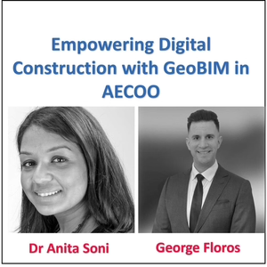
#17 - Dr Anita Soni & George Floros - Empowering Digital Construction with GeoBIM in AECOO
Delve into our podcast episode on GeoBIM integration in Architecture, Engineering, and Construction (AEC). This episode unveils the full AECOO (Architecture, Engineering, Construction, Owner, Operator) or out simply, the whole life cycle of built assets.
Featured guests Dr. Anita Soni and George Floros from Skanska discuss BIM, GIS, and data management, emphasizing data visualization and real-time construction updates.
Discover Skanska's dedication to data compliance, engagement with standards bodies like the OGC, and alignment with the ISO 19650 series. They leverage automation for data accuracy and inspire their supply chain to uphold standards.
This conversation illuminates the essence of collaboration, shared insights, and the impact of evolving industry standards. Dive into the digital construction domain.
About Dr. Anita Soni:
Skanska Infrastructure UK's Pre-Construction BIM Lead, Anita possesses deep civil industry experience. Affiliated with the High Speed 2 Railway Civils Contract, she focuses on enhancing the synergy of Survey, BIM, and GIS throughout different phases. A Geomatic Engineering expert, Anita achieved her EngD from University College London, pioneering in non-contact technologies like laser scanning for railway infrastructure.
About Georgios (George) Floros:
George, Skanska UK-Infrastructure’s GIS Head, propels digital transformation via geospatial data. Prioritizing stakeholder benefits, he pioneers geospatial solutions minimizing risks. George's GeoBIM solution promotes business innovation using geospatial tech. He’s pursuing a PhD at University College London on GeoBIM Asset Management and has multiple relevant degrees.
References:
- BimTube Podcast #9 - Marc Goldman, Esri - Unlocking Geospatial Value
- BuildingSmart International
- CICES
- Digital Construction Week (DCW)
- GEO Business
- The B1M
- AEC and GeoBIM Industry Blog
#GeoBIMIntegration #AECOO #Skanska #DataCompliance #ISO19650 #AutomationInAEC #DigitalConstruction #DrAnitaSoni #GeorgeFloros #RealTimeUpdates
====
GET THE INTERNATIONAL INFORMATION MANAGEMENT 'BIM' STANDARDS!
ISO 19650 series and UK BIM Framework: http://www.iso19650.org/
====
Contact the BimTube Podcast by sending us a text message.
BimTube's Mission: "We want to build everyone’s digital knowledge with content and conversations to inspire and instigate 'Better Information Management' to enable - better decisions, better infrastructure, better services and better outcomes for our social, economic and environmental infrastructure."
- Visit the BimTube Podcast page: https://www.bim.tube
- BIM / ISO 19650 Training (sponsored): https://www.bimenable.com
If you like this episode you’ll love


Episode Comments
Generate a badge
Get a badge for your website that links back to this episode
<a href="https://goodpods.com/podcasts/bimtube-podcast-273439/16-james-kavanagh-surveying-and-geospatial-insights-33029575"> <img src="https://storage.googleapis.com/goodpods-images-bucket/badges/generic-badge-1.svg" alt="listen to #16 - james kavanagh - surveying and geospatial insights on goodpods" style="width: 225px" /> </a>
Copy